Returned Type:
XmlDocument
Returns an XML Document according to trackpointsloadpubbydate command with the following structure:
<?xml version="1.0" encoding="utf-8"?>
<furesult>
	<message><![CDATA[ OK ]]></message>
	<open>0</open>
	<photos>
		<photo>http://www.mysite.com/photo/name.kmz</photo>
	</photos>
	<points>
		<point>
			<latitude>44.5927777777778</latitude>
			<longitude>11.6555555555556</longitude>
			<accuracy>20</accuracy>
			<altitude>500</altitude>
			<altitudeaccuracy>15</altitudeaccuracy>
			<heading>10</heading>
			<speed>170</speed>
			<message><![CDATA[Ciao.]]></message>
			<type>0</type>
			<time>20131031123026</time>
		</point>
		<point>
			<latitude>44.62</latitude>
			<longitude>11.70</longitude>
			<accuracy>20</accuracy>
			<altitude>500</altitude>
			<altitudeaccuracy>15</altitudeaccuracy>
			<heading>30</heading>
			<speed>270</speed>
			<message><![CDATA[Ciao.]]></message>
			<type>0</type>
			<time>20131031124000</time>
		</point>
	</points>
</furesult>
Where
- <message> contains OK or Error description
- <open> identify an open track and can be:
- 0 (zero) – all tracks are closed
- 1 (one) – an open track is present
- <photos> this node may contain a collection of pictures' files.
- <photo> this tag can be repeated many times as more than one KMZ file cloud be present. Each node contains the URL of a KMZ file that shows the pictures linked to the track
- <points> this node contains the points forming the track:
- <point> at least one point have to exists. Every single <point> node contains:
- <latitude> the point's latitude in degree and decimal degrees. If the position is in the southern hemisphere the value will be negative so it will be preceded by a minus sign
- <longitude> the point's longitude in degree and decimal degrees. If the position is in the western hemisphere the value will be negative so it will be preceded by a minus sign
- <altitude> the point's altitude in feet without decimal numbers
- <accuracy> the point's accuracy in meters without decimal numbers
- <altitudeaccuracy> the altitude's accuracy in feet without decimal numbers
- <heading> the direction of the vehicle in degrees from 0 to 359
- <speed> the detected speed expressed in meters per second and tenths of a meter per second
- <message> message sent along with the position. Maximum length is 1000 characters
- <type> The type of the position and can be:
- 0: standard
- 1: SOS
- 2: begin of activity
- 3: end of activity
- 4: button 1 pressed
- 5: button 2 pressed
- 6: button 3 pressed
- 7: button 4 pressed
- 8: state changed from motion to rest
- 9: state changed from rest to motion
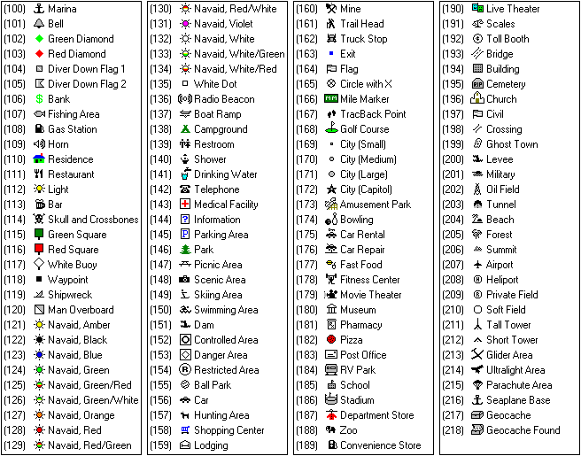
- 100~218: POI's (Point of Interest) category linked to the track. The categories are visible in the following table

- <time> UTC date and time of the position in yyyyMMddhhmmss format